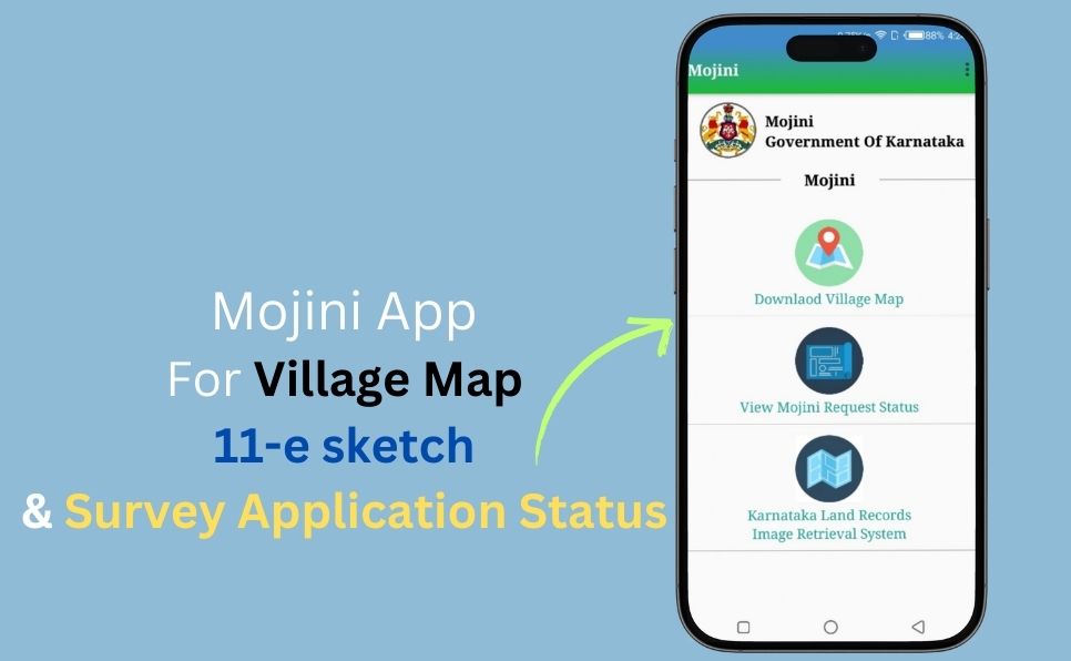
The Mojini V3 app is a digital initiative by the Karnataka Revenue Department, designed to make accessing land records and services more convenient for residents. This mobile app helps users easily track the status of land-related applications, download village maps, and view land record images, among other features.
In this article, we’ll explore the key features of the Mojini app, show you how to log in, and guide you through checking the 11E sketch using the mobile application.
What is the Mojini App?
The Mojini App is an Android application that allows users to access the Mojini V3 portal.
Developed by the Government of Karnataka, the Mojini app helps users to track application statuses, download land maps, and retrieve official land documents.
The app is available in the Google Play Store and is primarily available in Kannada. However, users can switch to the English version by selecting the language option from the menu.
Also Read: How to check Mojini V3 application status.
How to Login to Mojini V3 Mobile App
To access the Mojini V3 mobile app, follow these steps:
- Download the official Mojini app from the Google Play Store.
- Enter your username and password in the designated fields.
- Click on the “Login” button.
- You will be redirected to the dashboard, where you can access various services.
If you do not have a Mojini V3 username, you must register for an account before logging in. In case of login issues, users can contact the Karnataka Land Records Department for assistance.
Services Provided Under Mojini App

Mojini offers a range of land-related services to citizens, including:
Download Village Map
Users can access and download village maps through the Mojini app, enabling them to visualize land surroundings and identify property boundaries.
View Mojini Request Status
Citizens can track their land-related application statuses, including land allotment, survey requests, and sketch applications.
Karnataka Land Records Image Retrieval System
Mojini provides access to various land-related sketches, including:
- 11E Sketch: Displays the boundaries and extent of specific land plots.
- Allotment Sketch: Provides information on government land assigned to private entities.
- Phodi Sketch: Shows the entire land boundaries within a village.
- Revenue Maps: Allows users to access and view village revenue maps.
- Dispute Cases: Enables users to check land dispute reports by entering the required details.
- MIS Reports: Some reports may require an official login and user permissions.
- Official Circulars: Updates on Karnataka’s land policies and notifications are available within the app.
Apply for Land-Related Services
Citizens can apply for various services, including:
- 11E Sketch
- Land Conversion Sketch
- Haddubasthy Sketch
- Tatkal Podi Sketch
Fees for these services can be paid online directly through the app.
Request for Survey Documents
Mojini allows users to apply for survey documents such as Tippan, Pakka, Book, and Atlas. Users can also view these documents directly in the app.
How to Check 11E Sketch Application Status
To check the status of an 11E Sketch application, follow these steps:
- Open the Mojini App.
- Navigate to the “Sketches” section.
- Click on “Sketch View” (11E Sketch View).
- Enter the reference number manually.
- Click on “Proceed.”
- The land record will be displayed on the app.
FAQs
1. Can I use the Mojini app in English?
Yes, the Mojini app is primarily in Kannada, but users can switch to English by selecting the language option from the menu.
2. Is the Mojini app available for iOS?
Currently, the Mojini app is available only on the Google Play Store for Android devices.
3. Do I need to pay to access land records?
Some services, such as applying for an 11E Sketch or survey documents, require an online fee payment, while other information can be accessed for free.
4. What should I do if I forget my login credentials?
If you forget your username or password, you can use the “Forgot Password” option in the app or contact the Karnataka Land Records Department for assistance.
5. Can I track my application status through the app?
Yes, users can check the status of land-related applications, including sketch requests, land conversion, and survey documents, directly through the Mojini app.
The Mojini V3 mobile app is a valuable tool for Karnataka citizens, simplifying access to land-related information and services. With features like 11E sketch viewing, land dispute reports, and online survey document requests, the app ensures transparency and efficiency in land management.
By following the login and navigation instructions provided, users can seamlessly access and utilize the Mojini app for their land-related needs.

Vikas Kumar holds an MA in Political Science and has a strong background in government projects, having worked on various contractual initiatives aimed at public welfare. He created this website to share essential updates on government schemes, aiming to empower citizens with the information they need to access valuable resources.


This is very interesting, You are a very skilled blogger. I’ve joined your rss feed and look forward to seeking more of your wonderful post. Also, I have shared your site in my social networks!